PAGE CONTENTS
Objectives
The project’s first objective is to aid GEO satellite system dimensioning by performing long-term study of Ka-band propagation effects within the designated coverage areas at High North locations. The outcome of the study will be used to refine and enhance relevant ITU-R radio wave propagation models and prediction methods for geostationary orbiting satellites serving high latitude low elevation angle locations on land, coastal areas, and at sea. Results will also become important for other orbits.
A second objective is to perform telecom measurements involving traffic data for a Ka-Band satellite. It involves analyses to what degree telecom data relates to propagation information.
A third objective is to gain experience with Ka-band band system operated at High North locations, normally in more challenging conditions that lower latitude locations.

Challenges
The key challenge is to collect high quality measurement data from several stations all operated by remote control, and some being at remote non-manned locations. The data availability needs to be very high such that valid statistical analysis can be performed and reliable conclusions ensured.
System Architecture
The propagation data have been measured using the satellite Ka-Sat at 9.1° E and the telecom data collected using Thor 7 at 1° W. The measurement network of the stations was set up with a 24/7 surveillance capability.
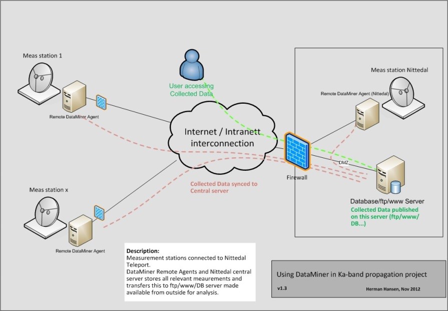
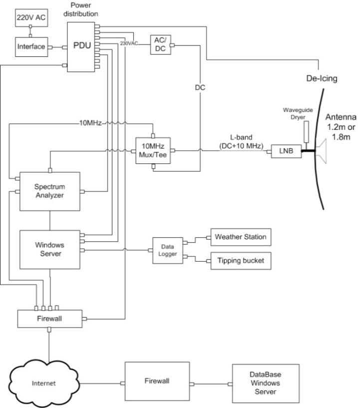
The propagation terminal consists of beacon measurement and meteorological stations. It collect and stores data locally, then at regular intervals upload data to the central sever.
The telecom experiment consisted of a fixed VSAT installation, using an iDirect Velocity modem running DVB-S2 on forward and MF-TDMA on return.
Plan
The project plan was as follows:
- 2012.09 Project kick-off meeting
- 2013.08 Propagation measurement start at the first station Nittedal
- 2013.10 Propagation measurement start at station Røst, the last before project extension
- 2015.07 Telecom measurement start
- 2015.10 Two-year propagation data completed
- 2015.12 Telecom measurement end
- 2016.04 Measurement start at Bjørnøya
- 2017.06 Projected completed with three years data collected at five stations, one year at one station, and six month telecom
Current Status
The project is completed with measured multiple year propagation data and six months telecom data from High North locations, several in maritime climates.
With 7-8 dB margin services can be provided at 99 % availability for elevation angles as low as 3.2 and 3 dB for elevation angles above 10.1°. Attenuation measurements support ITU-R prediction methods. Scintillation and multipath are not well predicted at the lowest elevation.
Telecom data were used to compare actual performance versus predicted and to verify the Thor 7 overall system performance. Results were used to improve the nominal spectral efficiencies on Thor 7.
Related Links
Companies